FREESE-NOTIS
EVENING WEATHER UPDATE
6:00 PM, Thursday, December 02, 2021

MIDWESTERN U.S.
6:00 PM CDT, Thu Dec 02, 2021
�MIDWEST U.S.� -
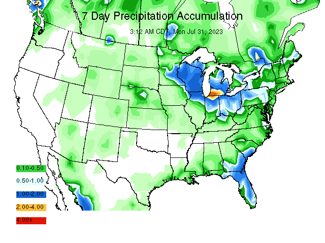
For the 1-5 day outlook December 2-December 7, corn belt temperatures will average near 44.1 F which is 11.2F from normal. Rainfall will average 0.37". Approximately 33% of the area will receive a 0.25" or more. This compares to the earlier estimate today of 78%.
For the 6-10 day outlook, December 7-December 11, the western corn belt temperatures will be ABOVE NORMAL. Rainfall will be ABOVE NORMAL. Eastern corn belt temperatures will be ABOVE NORMAL. Rainfall will be ABOVE NORMAL.
For the 11-15 day outlook December 12-December 16, the western corn belt temperatures will be ABOVE NORMAL. Rainfall will be ABOVE NORMAL. Eastern corn belt temperatures will be ABOVE NORMAL. Rainfall will be ABOVE NORMAL.

SOUTHEASTERN U.S.
For the 1-5 day outlook December 2-December 7, delta area temperatures will average near 59.3 F which is 12.7 F from normal. Rainfall will average 0.72". Approximately 100% of the area will receive a 0.25" or more. This compares to the earlier estimate today of 20%.
For the 6-10 day outlook, December 7-December 11, the Delta region temperatures will be N normal. Rainfall will be N normal. The southeast region temperatures will be ABOVE NORMAL. Rainfall will be ABOVE NORMAL.
For the 11-15 day outlook December 12-December 16, the Delta temperatures will be N normal. Rainfall will be N normal. The southeast region temperatures will be ABOVE NORMAL. Rainfall will be ABOVE NORMAL.
PLAINS
For the 1-5 day outlook December 2-December 7, winter wheat temperatures will average near 48.3 F which is 13.9 F from normal. Rainfall will average 0.06". Approximately 0% of the area will receive a 0.25" or more.. This compares to the earlier estimate today of 64%.
For the 6-10 day outlook, December 7-December 11, the winter wheat temperatures will be ABOVE NORMAL. Rainfall will be N normal.
For the 11-15 day outlook December 12-December 16, the winter wheat temperatures will be ABOVE NORMAL. Rainfall will be N normal.
NORTHERN PLAINS
For the 1-5 day outlook December 2-December 7, spring wheat temperatures will average near 31.0 F which is 10.5 F from normal. Rainfall will average 0.14". Approximately 18% of the area will receive a 0.25" or more. This compares to the earlier estimate today of 66%.
For the 6-10 day outlook, December 7-December 11, the spring wheat temperatures will be N normal. Rainfall will be N normal.
For the 11-15 day outlook December 12-December 16, the spring wheat temperatures will be N normal. Rainfall will be N normal.
NORTHEAST
For the 1-5 day outlook November 2-November 7, Megalopolis area temperatures will average near 48.3 F which is 1 from normal. Rainfall will average 0.54. Approximately 100% of the area will receive a 0.25" or more. This compares to the earlier estimate today of 100%.
For the 6-10 day outlook, December 7-December 11, The Megalopolis temperatures will be ABOVE NORMAL. Rainfall will be ABOVE NORMAL.
For the 11-15 day outlook December 12-December 16, The Megalopolis temperatures will be ABOVE NORMAL. Rainfall will be ABOVE NORMAL.
SOUTH AMERICAN TEMPERATURE AND PRECIPITATION MAPS
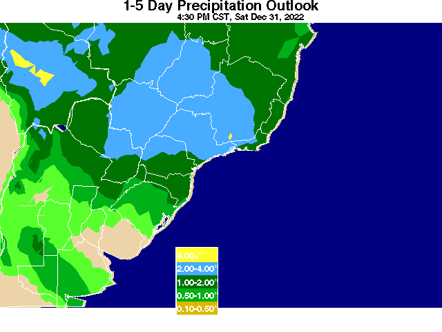
For the 1-5 day outlook November 27-December 2, Brazil Corn area temperatures will average near 77.0 F which is 2.2 from normal. Rainfall will average 0.33". Approximately 51% of the area will receive a 0.25" or more. This compares to the earlier estimate today of 51%.
For the 6-10 day outlook November 28 -December 2, Brazil Corn area temperatures will average near 74.5 F which is -.5 from normal. Rainfall will average 0.30". Approximately 54% of the area will receive a 0.25" or more.
ARGENTINA SOYBEANS
For the 1-5 day outlook November 2-November 7, Argentina Corn/Soybeans area temperatures will average near 63.8 F which is -1.9 from normal. Rainfall will average 0.37". Approximately 83% of the area will receive a 0.25" or more. This compares to the earlier estimate today of 25%.
For the 6-10 day outlook November 8 -November 12, Argentina Corn/Soybeans area temperatures will average near 70.3 F which is 3.8 from normal. Rainfall will average 0.33". Approximately 71% of the area will receive a 0.25" or more.


Copyright 2016
Richard Garuckas/Meteorologist
Freese - Notis Weather
Des Moines, IA 50312
Tel (515) 323-6016
E-mail hfreese@weather.net
Twitter @freesenotiswx
To subscribe to our weather app please go to
snappy.appypie.com/appbuilder/appystore/translucidus-6179d1b05e27
|