7:00 AM CDT, Wednesday, May 15, 2019
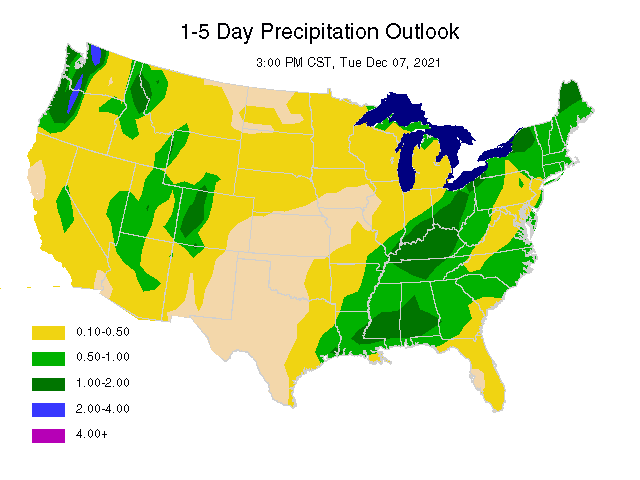
MIDWEST - 1 to 5 day temps above normal central and south, near normal north. Above normal precipitation during this time in the northwest half with near to below normal rainfall southeast. 6 to 10 day temps above normal for the southeast 2/3 of the region and near to below normal northwest portion. Above normal rainfall northwest half for the 6-10 day outlook with near normal southeast. Overall, this should allow for more drying time in the southeast half of the area for fieldwork.
DELTA/SOUTHEAST - 1 to 5 day outlook is for above normal temps in the Delta and near to above Southeast. Near to below normal rainfall in the Delta and below normal Southeast. For the 6 to 10 day period, above normal temps across the region and mostly below normal precipitation.
NORTHERN 1/2 PLAINS - 1 to 5 day temps near to below normal while precipitation will be above average. Cool and wet for the 6-10 day outlook with below normal temps and above normal precipitation.
SOUTHERN 1/2 PLAINS - 1 to 5 day temps near to above normal. Near to below normal rainfall west half and near to above east. Cooling to below normal for the 6-10 day outlook with near normal rainfall west and above normal east.
CROP IMPACTS
MIDWEST - Some scattered rain at times through Friday, but there will be enough dry time in some areas for fieldwork and crop planting. More delays and slowdowns during the 6-10 day period, especially northwest during the 6-10 day outlook. Drier weather southeast half will allow for increasung crop planting at this time.
DELTA/SOUTHEAST - Drier trend will be more favorable for crop planting. The Southeast eventually need some rain by the 11-15 day outlook if the drier outlook persists.
NORTHERN 1/2 PLAINS - Some crop planting through late week where rainfall is less. Increasingly wetter trend by the weekend and into next week will delay crop planting.
SOUTHERN 1/2 PLAINS - Much of the area will have good fieldwork conditions for the 1-5 day outlook, a few showers north portion may slow fieldwork temporarily. A wetter trend for the 6-10 day period in the east will benefit newly planted crops and delay some fieldwork.
PAST WEATHER AND SHORT-RANGE FORECAST

MIDWESTERN U.S. (NE to OH and southern MN to southern IL)
Highs on Tuesday were mostly 60's east of the Mississippi River and ranged up to the 80's far west. Scattered showers produced some .10-.50" amounts in IA and western IL the past 24 hours.
Some widely scattered showers will fall through Friday, but the next main system will hold off until the weekend and into early next week.The northwest half of the region will receive 1.00-3.00" inches for 5 day rainfall, and somewhat less southeast with .25-1.00", but very little far southeast. Highs will be warming into the 80's in the west the next several days and near 90 far west tomorrow. The east will be cooler with highs in the 60's and 70's the next few days, a little warmer Friday into the weekend.
 SOUTHEASTERN U.S. (Delta east to Carolinas)
Highs Tuesday were in the 70's Southeast and upper 70's andd low 80's Delta. It was dry across the region the last 24 hours.
Much of the region will be dry through late week, but some isolated showers will fall in the Delta and far western Southeast the next few days. 5 day rainfall will be .10-.50" in the Delta and very little or no rain Southeast. Highs will be warming into the 80's across the region the rest of the week.
NORTHERN PLAINS (eastern MT to northwest MN)
Highs yesterday were in the 70's and low 80's with dry weather.
Scaattered showers at times into late week then more showers this weekend with .50-2.00" amounts foir the weekend.
SOUTHERN PLAINS (southern NE to northern TX)
Highs yesterday were in the 80's anda few low 90's with dry weather.
Mostly dry into late week then some scattered showers late Friday into the weekened.
NORTHEASTERN U.S. MEGALOPOLIS
Temperatures averaged near 51.9 F. Rainfall averaged 0.61". The most rainfall recorded was 0.77".
For the 1-5 day outlook May 15-May 20, Megalopolis area temperatures will average near 60.4 F which is -3.7 from normal. Rainfall will average 0.40". Approximately 75% of the area will receive a 0.25" or more. This compares to the earlier estimate today of 100%.
EXTENDED OUTLOOK AND GENERAL OVERVIEW OF U.S. PATTERN
The trend for cooler northwest and warmer southeast along with wetter northwest and drier southeast across the Midwest will continue into the 11-15 day period.
Copyright 2017
WAYNE ELLIS/METEOROLOGIST
Freese - Notis Weather
Des Moines, IA 50312
United States of America
Tel (515) 282-9310
E-mail
hfreese@weather.net
IM: weathertrader89
Twitter: @freesenotis
Web Page Design Revised last - June 14, 2010